


Einführung/Introduction Botswana
Botsuana (Botswana) ist ein 582.000 km² umfassendes Binnenland im Zentrum des südlichen Afrika. Der Okavango im Nordwesten des Landes zählt zu den größten Flüssen Afrikas. Er bildet das Okavango Delta, das als UNESCO-Weltkulturerbe anerkannt ist. Botsuana ist relativ flach, durchschnittlich 900 Meter über dem Meeresspiegel. Die Kalahari-Wüste macht über 70 Prozent der Landesfläche aus.
Weitere Informationen zu Botsuana
Botswana is a completely landlocked country in the centre of Southern Africa. One of Southern Africa’s longest rivers, the Okavango, flows into the north-western part of the country, forming the UNESCO World Heritage Site Okavango Delta. Botswana shares borders with South Africa, Namibia, Zambia and Zimbabwe. The country covers an area of about 582,000 sq.km² and is relatively flat, at roughly 900 metres above sea level, with gentle undulations and occasional rocky outcrops. The Kalahari Desert occupies more than 70 % of the country, with valleys and pans etched across the landscape.
Sources: https://www.cbd.int/countries/profile/?country=bw
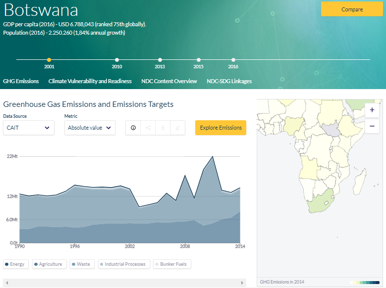
Climate Watch Data / Klimadaten: Botswana
Source: SDG Linkages Northrop, E., H. Biru, S. Lima, M. Bouye, and R. Song. 2016. “Examining the Alignment Between the Intended Nationally Determined Contributions and Sustainable Development Goals.” Working Paper. Washington, DC: World Resources Institute. Available online at: www.climatewatchdata.org